" class="zoomMainImage swiper-slide">
"
" alt="1771 Bonne Map of East Africa (Ethiopia, Sudan, ventes exceptionnelles Red Sea)" width="527" height="527" />1771 Bonne Map of East Africa (Ethiopia, Sudan, Red Sea) 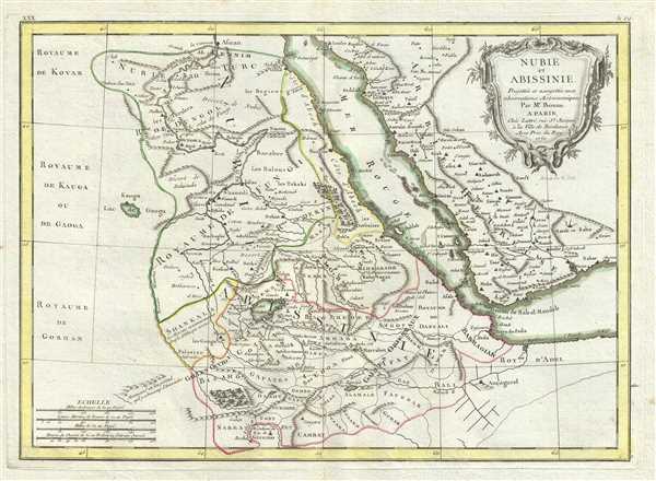 WE SELL ONLY ORIGINAL ANTIQUE MAPS - NOT REPRODUCTIONS Title: Nubie et Abissinie Projettee en assujettie aux observations Astronomiques. Description: A beautiful example of Rigobert Bonnes 1771 map of Nubia and Abyssinia. Covers from Aswan, Egypt south along the Nile river to include all of modern day Sudan, Ethiopia, Eretria, Djibouti and Somalia. Also includes parts of neighboring Arabia across the Red Sea. This is a fairly advanced map revealing the cartographic sophistication of the Abyssinian Empire. Shows the Blue Nile flowing correctly into Lake Dambea (Lake Tana) from the south. Notes numerous important cataracts on the Blue Nile. The White Nile, whos course is more mysterious, acts as a kind of western border for this map, with only vague notations regarding the African empires lying on its western shores. Names numerous Nubian and Ethiopian cities and monasteries as well as the location of Mecca across the Red Sea. A fine map of the region. Drawn by R. Bonne in 1771 for issue as plate no. A 29 in Jean Lattres Atlas Moderne. Size: Printed area measures 12 inches high by 17 inches wide. Condition: Very good. Some toning and wear along original centerfold. Minor foxing. Original platemark visible. Shipping: Shipping rates are not negotiable. Items are shipped within three business days of receiving payment. We are happy to consolidate shipping where possible. The following shipping options are available: 1. FedEx Overnight (45 USD). USA Only. Signature Required. Customs: International buyers are responsible for paying duty and taxes on delivery. DHL or FedEx will contact the buyer by telephone to arrange tax payment if it is levied. Duty varies by country and we cannot predict the amount you will be charged. Some countries are duty free, others are not. Typically, a customs duty and/or VAT tax will be assessed on all parcels to continental Europe. Sometimes duty or tax is due in China, but is seems very random. Hong Kong, Singapore, Korea, and Taiwan have never assessed duty on a map we shipped. Maps shipped to the UK should be duty free as educational materials, but from time to time duty of 5% is assessed incorrectly by the UK customs agents. Insurance: All shipments are insured privately against loss and damage. All of our shipments require a signature for insurance purposes. If you have any questions please feel free to email us through eBay. Other Services Conservation Framing: Geographicus recommends basic conservation framing services for any antique paper. We do not offer this service. |

