1772 Vaugondy - Diderot Map of Asia and the Northeast Passage 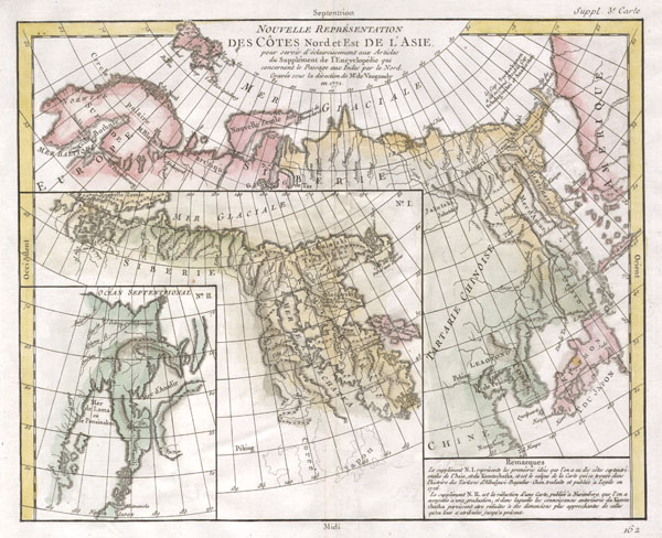 WE SELL ONLY ORIGINAL ANTIQUE MAPS - NOT REPRODUCTIONS Title: Nouvelle représentation Des Côtes Nord et Est de lAsie : pour servir déclaircissement aux Articles du Supplement de LEncyclopedie qui concernent le passage aux Indes par le Nord. Description: A comparative map of the three conflicting theories on the Northeast Passage, the northeast coasts of Asia, and the American Northwest. The Northeast Passage, much like Americans Northwest Passage, was a long sought after sea route through the Arctic that would save European merchantman the expense of rounding Africa in order to access the trade riches of East Asia. This map, in one of the first obtainable examples of comparative cartography, lays out three theories regarding the Northeast of Asia. Knowledge of this area was, at the time, speculative at best. Shows many unknown island, misshapen representations of Kamtschaka, Japan, Hokkaido (Yesso), Alaska, and the Behring Archipelago. Notes Peking (Beijing), Nanking (Nanjing), Corea (Korea), Jedo (Tokyo)and Nangasaki (Nagasaki). This map is part of the 10 map series prepared by Vaugondy for the Supplement to Diderots Encyclopédie, of which this is plate 3. This seminal map series, exploring the mapping of North American and specifically the Northwest Passage was one of the first studies in comparative cartography. Size: Printed area measures 12 inches high by 15 inches wide. Condition: Very good condition. Original centerfold as issued. Original wide clean margins. Platemark visible. Blank on verso. Shipping: Shipping rates are not negotiable. Items are shipped within three business days of receiving payment. We are happy to consolidate shipping where possible. The following shipping options are available: 1. FedEx Overnight (45 USD). USA Only. Signature Required. Customs: International buyers are responsible for paying duty and taxes on delivery. DHL or FedEx will contact the buyer by telephone to arrange tax payment if it is levied. Duty varies by country and we cannot predict the amount you will be charged. Some countries are duty free, others are not. Typically, a customs duty and/or VAT tax will be assessed on all parcels to continental Europe. Sometimes duty or tax is due in China, but is seems very random. Hong Kong, Singapore, Korea, and Taiwan have never assessed duty on a map we shipped. Maps shipped to the UK should be duty free as educational materials, but from time to time duty of 5% is assessed incorrectly by the UK customs agents. Insurance: All shipments are insured privately against loss and damage. All of our shipments require a signature for insurance purposes. If you have any questions please feel free to email us through eBay. Other Services Conservation Framing: Geographicus recommends basic conservation framing services for any antique paper. We do not offer this service. |

1772 Vaugondy - Diderot Map of Asia and the Northeast Passage WE SELL ONLY ORIGINAL ANTIQUE MAPS - NOT REPRODUCTIONS Title: Nouvelle représentation Des Côtes Nord et Est de lAsie : pour servir déclaircissement aux Articles du Supplement de LEncyclopedie qui concernent le passage aux Indes par le Nord. Description: A comparative map of the three conflicting theories on the Northeast Passage, the northeast coasts of Asia, and the American Northwest. The Northeast Passage, much like Americans Northwest Passage, was a long sought after sea route through the Arctic that would save European merchantman the expense of rounding Africa in order to access the trade riches of East Asia. This map, in one of the first obtainable examples of comparative cartography, lays out three theories regarding the Northeast of Asia. Knowledge of this area was, at the time, speculative at best. Shows many unknown island, misshapen representations of Kamtschaka, Japan, Hokkaido (Yesso), Alaska, and the Behring Archipelago. Notes Peking (Beijing), Nanking (Nanjing), Corea (Korea), Jedo (Tokyo)and Nangasaki (Nagasaki). This map is part of the 10 map series prepared by Vaugondy for the Supplement to Diderots Encyclopédie, of which this is plate 3. This seminal map series, exploring the mapping of North American and specifically the Northwest Passage was one of the first studies in comparative cartography. Size: Printed area measures 12 inches high by 15 inches wide. Condition: Very good condition. Original centerfold as issued. Original wide clean margins. Platemark visible. Blank on verso. Shipping: Shipping rates are not negotiable. Items are shipped within three business days of receiving payment. We are happy to consolidate shipping where possible. The following shipping options are available: 1. FedEx Overnight (45 USD). USA Only. Signature Required. Customs: International buyers are responsible for paying duty and taxes on delivery. DHL or FedEx will contact the buyer by telephone to arrange tax payment if it is levied. Duty varies by country and we cannot predict the amount you will be charged. Some countries are duty free, others are not. Typically, a customs duty and/or VAT tax will be assessed on all parcels to continental Europe. Sometimes duty or tax is due in China, but is seems very random. Hong Kong, Singapore, Korea, and Taiwan have never assessed duty on a map we shipped. Maps shipped to the UK should be duty free as educational materials, but from time to time duty of 5% is assessed incorrectly by the UK customs agents. Insurance: All shipments are insured privately against loss and damage. All of our shipments require a signature for insurance purposes. If you have any questions please feel free to email us through eBay. Other Services Conservation Framing: Geographicus recommends basic conservation framing services for any antique paper. We do not offer this service. |

